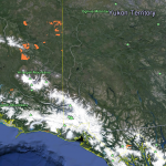
Our Copper River map shows there are currently 3,966 active gold mining claims, and 325 abandoned claims located on state lands. Fans of the reality show “Gold Rush™” can see Fred Hurt’s claim on Porcupine Creek—and discover a lot of claimable land in the surrounding area.
- When you first open our Copper River map you’ll see most of the gold mining activity takes place in the northeast corner of the meridian just above the Wrangell Mountains, just south of the Klondike. More activity can be found just north of Haines Alaska—which is where Fred Hurt’s “Jim Nail Claim” can be found.
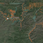
- Now zoom in about 180 miles southeast of Fairbanks to a little town called Chicken Alaska. You are now about 30 miles from the Canadian border and in the heart of gold rush country. The blue boundaries are abandoned claims and the gold boundaries are active claims. Note the placer claims that follow the river systems in the area. There is a lot of unclaimed land in this area.
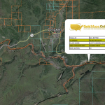
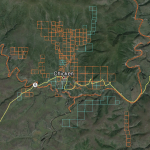
- Zoom in further still and you can see unclaimed sections of Chicken Creek and other water systems just south of town. The claim boundaries and acreage we show are accurate and should be what you find on the ground. Click on any claim for ownership information. Take the owners name and MTRS value to the Alaska Department of Mineral Resources for contact info if you want to lease a claim.
- At this point we usually show you where the local ranger station is or note where the trails and campgrounds are located, but there are none. You are in the Alaska wilderness now… The only access to Chicken is by airplane or the Taylor Highway. The highway is hard-packed gravel and is closed during the winter. Be sure to bring everything you’ll need, including guns. You’ll be in bear and moose country.
Copper River Gold Mining Notes: None of the images above show just how close you can zoom in and see potential prospecting sites. You’ll be amazed at how crisp the satellite imagery is and how much exploring and planning you can do from the comfort of your home.


